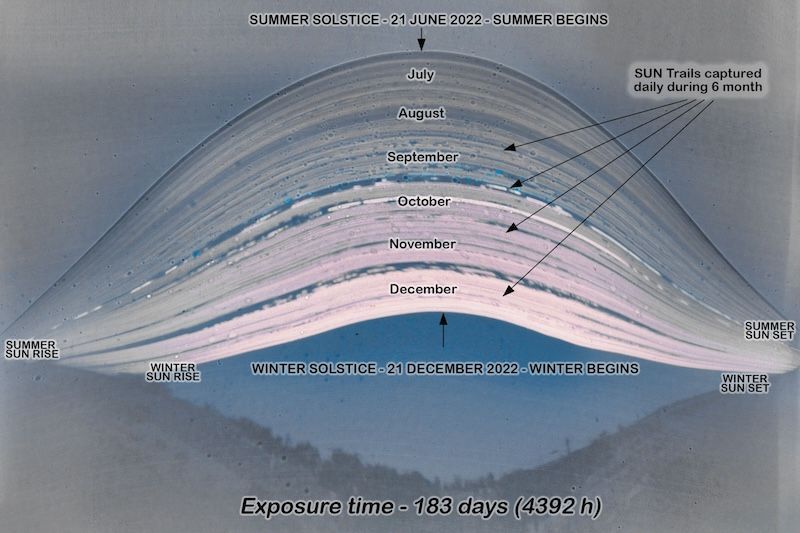
Layered curving lines forming a bulging shape in the sky, with curved horizon below and black text labels.José Palma in Mina São Domingos, Portugal, shared this incredible image with us. It’s an example of the art of solarigraphy, using long-exposure photography to capture the sun’s journey across the sky, day after day, over seasons.José wrote: “The image clearly shows the sun at its highest point in the sky on June 21st, which corresponds to a greater number of hours of daylight, and progressively decreases its altitude until the lowest point in the sky on December 21st. We can also observe dark areas in the months of July, August and September corresponding to clear and almost cloudless skies and from October onwards the increase in clouds meaning a lesser effect of the sun’s rays on the photographic paper.”Amazing job! Thank you, José. The image was taken using photographic paper inside of a pinhole camera. It was scanned after the 6 month exposure and then post-processing was done with Photoshop, using curves. This is the same path that the sun has followed this year, and the path it will take next year, and the next.
An interesting image for the first day of spring. Obviously, the same image stands in for this half of the cycle.

Sun pillar in Arkansas. They occur around the world. Still beautiful and special to see. Paula Dawn Sweet
Quite a few were seen during the January polar vortex. Caused by low angled light hitting ice crystals in the air.